Travel through a world of contrast: where mountains meet oceans and deserts touch grasslands
Regions
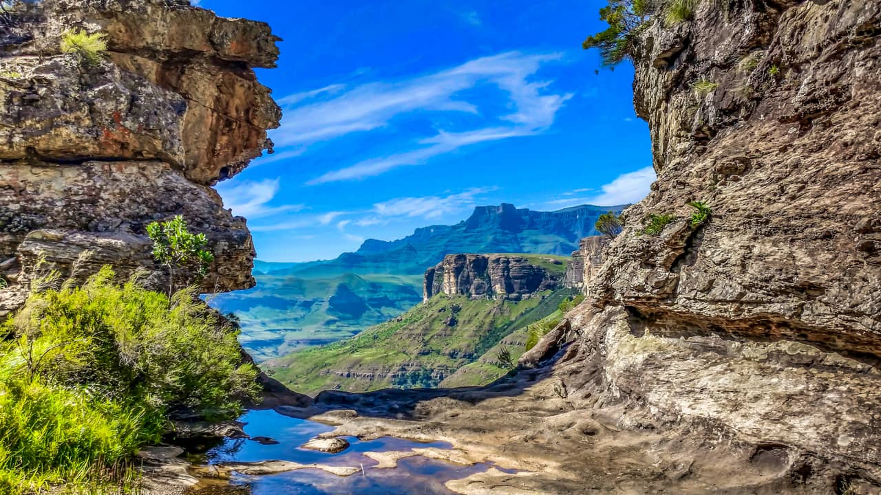
On many levels, South Africa is a diverse country. This is not only visible in its flora and fauna, but also on a geographical level. If you look at the landmass of South Africa, it can be divided into two categories: the interior plateau and the land between the plateau and the coast. These two categories are separated by the Great Escarpment, the most prominent relief feature in the country.
The escarpment runs parallel to the coastline, from the Northern Cape in the west all the way up north in the Limpopo province in the east. The height varies between 1500m to almost 3500m above sea level. The high peaks and deep valleys of the escarpment create many micro climates and often prevents the rain from reaching the interior plateau.


This diversity in landscape and climate ensures that South Africa has 9 different biomes (a distinct geographical region with specific climate, vegetation and animals). These biomes range from dry and arid (almost dessert like) conditions to subtropic forests, and from savanna and grassland to the vegetation richness of the Fynbos.
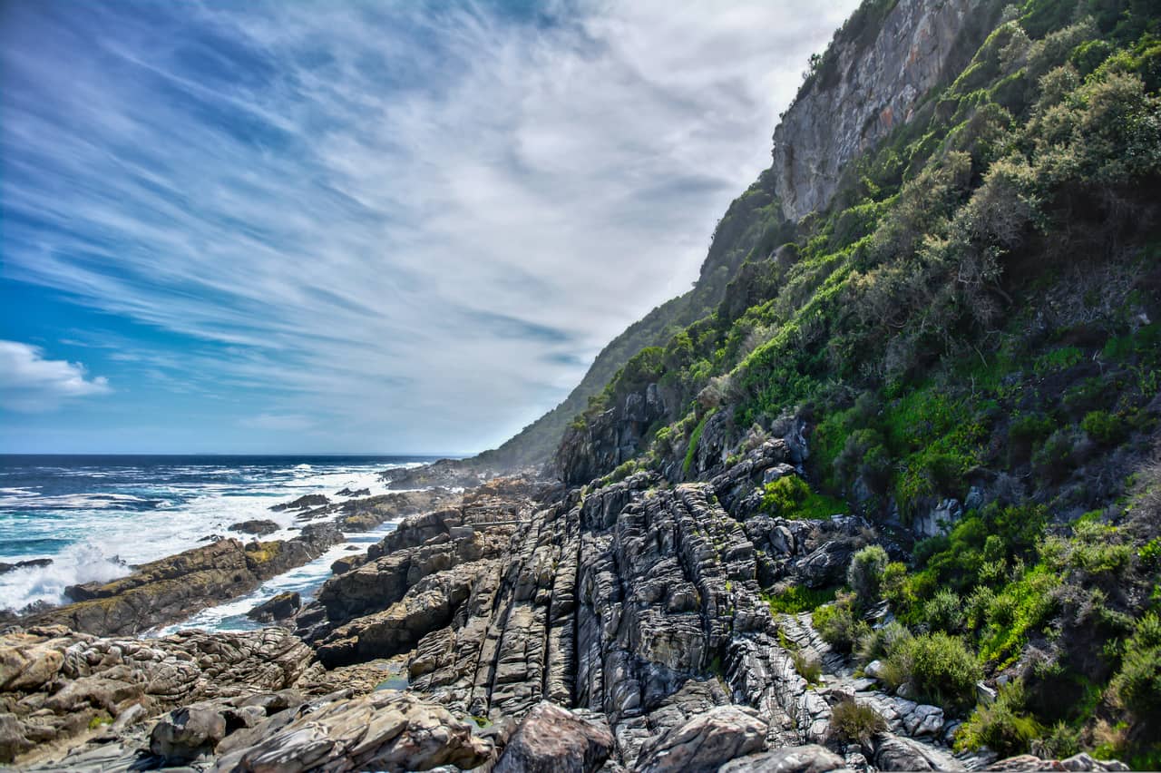
Just off shore you can see the same diversity. The African continent lies between two different oceans and at the southern tip, they collide. From the east, the warm waters of the Indian Ocean pass along the coastline to the west. At the same time from the south, the cold waters of the Atlantic Ocean pass along the west coast to the north. Somewhere around Cape Agulhas these two currents meet, and clash. Creating nutrient rich waters where marine life can thrive, but also creating significant differences in climate.


The regions in South Africa tell the same story of diversity. They can be very mountainous or relatively flat, very lush and green or arid and rocky, they can support many large grazers and predators or hardly any large mammals at all. But they all have in common that they are bursting with life, even if it is not so obvious to the eye.
All of these things ensure that South Africa ranks very high on the diversity scale. Just 1% of the total land of the world, provides 10% of all the bird, fish and plant species and 6% of all the mammal and reptile species. It is often said that South Africa has the diversity of an entire continent within its borders.


WHERE
ARE THE REGIONS
LOCATED
WHERE TO GO

Cape Peninsula
The Cape Peninsula is one of those rare places where a major city and wild nature exist side by side. Framed by mountains and surrounded by water on two sides, this region feels less like a single destination and more like a collection of landscapes gathered around one dramatic coastline.
At its heart rises Table Mountain, a flat-topped landmark that defines the skyline and anchors a network of peaks, ridges, and valleys. Lion’s Head and Signal Hill overlook the Atlantic Seaboard, while the Cape Peninsula stretches south toward Cape Point, where cliffs plunge into restless seas. Along this rugged coastline, white-sand beaches like Camps Bay and Clifton contrast with rocky coves and kelp-fringed shores.
On either side of the mountains, the coastline changes character. The Atlantic side is typically cooler and more rugged, with rocky shores, kelp forests, and windswept beaches backed by steep slopes. The False Bay side is generally more sheltered, with longer sandy beaches, tidal flats, and warmer waters. Coastal habitats include dunes, estuaries, and small wetlands that attract seabirds and marine life.
Nature is woven into daily life here. Protected areas safeguard rare Fynbos vegetation, while hiking trails, tidal pools, and scenic drives make exploration easy. Within a short distance, you can watch the sunset over the Atlantic, wander through indigenous forest on the slopes of the peninsula, or stand above the city with panoramic views that stretch from ocean to mountains.

Drakensberg
The Drakensberg region is one of the country’s most dramatic mountain landscapes. Stretching along the eastern edge of the interior plateau, this vast highland forms a natural boundary with Lesotho and creates a skyline of towering cliffs, high ridges, and sweeping alpine views.
Here, the land rises sharply from rolling foothills to some of the highest elevations in southern Africa. The escarpment is crowned by broad, windswept plateaus and steep basalt walls that drop into deeply carved valleys below. Many of South Africa’s major rivers begin in these mountains, fed by summer rains, mist, and winter frost that gather along the high ground.
The landscapes shift noticeably with altitude. Lower slopes are covered in grassy hills and scattered woodland, while higher elevations open into montane and alpine grasslands where conditions are cooler and more exposed. Sheltered ravines and sandstone cliffs often hold pockets of indigenous forest, creating striking contrasts between open highlands and shaded green valleys.
The region is also rich in cultural history. Rock shelters tucked into the sandstone formations contain ancient San rock art, preserved within protected reserves and offering insight into the long human connection to this mountainous environment.

Greater Kruger
The Greater Kruger region stretches across the northeastern corner of South Africa, covering a vast sweep of Limpopo and Mpumalanga. At its heart lies Kruger National Park, surrounded by a network of private and provincial reserves that share open boundaries with the park, creating one of Africa’s largest and most intact wildlife landscapes.
This is classic African safari country. Wide plains dotted with acacia, marula, and knobthorn trees give way to riverine forests along seasonal and permanent waterways such as the Sabie, Olifants, and Letaba rivers. The terrain varies from open grasslands that allow long views across the savanna to denser thickets where animals move quietly through the shade. Seasonal changes shape the experience: summer rains bring lush vegetation and newborn wildlife, while the dry winter months concentrate animals around water sources, making game viewing especially rewarding.
The region is globally known for its abundance and diversity of wildlife. Visitors have the chance to encounter the iconic Big Five alongside large populations of giraffe, zebra, wildebeest, and numerous antelope species. Predators such as lion, leopard, cheetah, and African wild dog roam freely across the unfenced reserve system. Birdlife is equally impressive, with hundreds of species ranging from colorful bee-eaters to imposing raptors.

Overberg
The Overberg lies just east of Cape Town, a broad sweep of coastline, rolling farmland, and rugged mountains that stretches from the Hottentots Holland range to Witsand. It is a region shaped by wind, ocean, and seasonal change, where fertile valleys meet dramatic cliffs on the coastline.
Nature here is defined by variety. Inland, gentle hills are quilted with wheat fields and Renosterveld, one of South Africa’s most threatened vegetation types. Along the mountains and coastal plains, Fynbos dominates, filling the landscape with proteas, ericas, and restios that flower in waves through winter and spring. During good rainfall years, wildflower displays transform open veld into a patchwork of color.
The coastline is one of the Overberg’s greatest highlights. The seaside town of Hermanus is world-famous for its land-based whale watching, especially between June and November when Southern Right Whales gather in Walker Bay to calve. Rocky shores, sandy beaches, and estuaries also support dolphins, seals, and rich birdlife, from African Black Oystercatchers to flocks of flamingos in sheltered lagoons.
A network of protected areas preserves these landscapes. De Hoop Nature Reserve is a standout, combining limestone Fynbos, coastal dunes, wetlands, and a long, quiet stretch of beach that offers some of the best whale viewing in the country. Agulhas National Park protects the southernmost tip of Africa, where the Atlantic and Indian Oceans meet amid windswept plains, historic shipwrecks, and important wetlands. Smaller reserves and conservancies throughout the region safeguard Renosterveld fragments and mountain habitats.

Wild Coast
The Wild Coast stretches along South Africa’s remote Eastern Cape shoreline, running roughly between East London and the border with KwaZulu-Natal. True to its name, this is a place where the landscape still feels untamed. Rolling green hills spill down toward the Indian Ocean, cliffs rise above pounding surf, and long, empty beaches curve between river mouths and rocky headlands.
Much of the region sits at relatively low elevations near the coast, but the terrain is far from flat. A series of deeply cut river valleys, including the Mbashe, Mthatha, and Umzimvubu, carve their way from the inland plateau to the sea. These rivers create steep gorges, fertile floodplains, and dramatic estuaries that shape both the scenery and the ecosystems. In places like Port St Johns, forested hills climb sharply from the water, giving the coastline a rugged, layered appearance.
The Wild Coast’s geology produces striking coastal features. Sandstone cliffs and wave-cut platforms frame stretches of golden sand, while offshore reefs and rocky points attract seabirds and marine life. One of the region’s most iconic landmarks is Hole-in-the-Wall, a natural sea arch carved by centuries of waves. Along the shore, the constant motion of the Indian Ocean keeps the coastline dynamic, reshaping beaches and sculpting new formations over time.
Vegetation reflects the area’s warm, moist climate. Coastal grasslands dominate the open hills, interspersed with pockets of indigenous forest in sheltered valleys and along riverbanks. Mangroves occur in some estuaries, and dune systems support specialized plant communities adapted to wind and salt spray. This mix of habitats supports a rich variety of wildlife, from dolphins offshore to birdlife in the wetlands and forests.

Cape Winelands
The Cape Winelands is one of South Africa’s most scenic inland regions, where fertile valleys lie cradled between rugged mountain ranges. Just a short drive from Cape Town, the landscape feels distinctly rural, defined by vineyards, historic towns, and dramatic natural backdrops.
The region sits within the Cape Fold Belt, a series of ancient folded mountains that rise sharply from the valley floors. Peaks such as the Stellenbosch Mountains and the Franschhoek mountains create a striking setting of steep slopes, rocky ridges, and narrow passes. Elevations increase quickly from the cultivated lowlands to higher ground covered in Fynbos, offering sweeping views across patchwork vineyards and orchards below.
Seasonal changes are easy to see here. Spring brings fresh green growth and wildflowers along field margins, while autumn colors the vineyards in shades of gold and red against the grey and green mountain slopes.
Beyond the cultivated land, much of the higher terrain is protected within mountain reserves that preserve natural Fynbos vegetation. These areas provide important water catchments and create opportunities for hiking through rugged terrain, shaded ravines, and panoramic ridgelines.

Garden Route
The Garden Route is one of South Africa’s most celebrated natural corridors, stretching along the southern coast between Witsand and the Storms River. This region is known for its lush scenery and the way ocean, forest, rivers, and mountains lie close together, creating constant variety over relatively short distances.
The coastline alternates between long sandy beaches, rocky headlands, and sheltered bays. Warm currents from the Indian Ocean bring milder sea temperatures than the Atlantic side of the country, supporting rich marine life and making the shoreline ideal for activities such as coastal walks, kayaking, and wildlife viewing. Estuaries and lagoons, particularly around Knysna, form calm waterways that connect freshwater and marine ecosystems.
Inland from the coast, the landscape rises into dense indigenous forests. These forests are among the last large remnants of South Africa’s ancient woodland, filled with towering yellowwood trees, ferns, and shaded river valleys. The environment here feels cool and sheltered, with hiking trails that weave through thick vegetation and along clear streams.
Beyond the forests, mountain ranges form the inland boundary of the region. These ridges are often covered in Fynbos and montane vegetation, creating elevated viewpoints that look back across the green valleys toward the ocean. Rivers flowing from these highlands carve gorges and feed waterfalls before reaching the sea.

Little Karoo
The Little Karoo is a long, arid valley that stretches between the Swartberg Mountains to the north and the Langeberg and Outeniqua ranges to the south in South Africa’s Western Cape. It feels like a world apart from the lush coast just over the mountains. Here the landscape opens into wide horizons, stony plains, and folded hills shaped by time, wind, and sparse rainfall.
Despite its dry appearance, the Little Karoo is surprisingly rich in life. Much of the region falls within the Succulent Karoo biome, one of the most botanically diverse arid areas on Earth. After seasonal rains, the veld can burst into color as wildflowers carpet the ground, while hardy succulents, aloes, and dwarf shrubs thrive year-round. This resilience gives the landscape a subtle beauty that reveals itself slowly, especially to those who spend time exploring on foot.
Wildlife is adapted to the harsh conditions. Smaller antelope such as Klipspringer, Steenbok, and Grey Rhebok move through rocky terrain, while birds like Ludwig’s Bustard, Pale Chanting-Goshawk, and a variety of larks are common sights. Reptiles are also well represented, taking advantage of the warm, dry climate.

Panorama Route
The Panorama Route winds along the edge of South Africa’s Great Escarpment in Mpumalanga, where the Highveld suddenly drops toward the Lowveld of the Greater Kruger region. It is a landscape built for big views. Forested plateaus, deep river canyons, and sheer cliffs create one of the most scenic drives in the country.
At the heart of the region lies the Blyde River Canyon, one of the largest green canyons on Earth. Unlike many desert canyons, its slopes are covered in dense subtropical vegetation, with rivers cutting through layers of ancient rock. Viewpoints such as God’s Window, Wonder View, and the Three Rondavels reveal sweeping vistas that stretch across the escarpment toward the distant plains.
Water has shaped much of what visitors see here. The Blyde and Treur Rivers have carved dramatic features over millions of years, including Bourke’s Luck Potholes, where swirling currents have sculpted smooth, cylindrical rock pools. Numerous waterfalls tumble over the escarpment after summer rains, including Lisbon Falls and Berlin Falls, adding movement and sound to the rugged terrain.

